
Globe Trotter in Brasil - powered by Munganga
Day 3,309, 12:00
•
Published in Brazil  •
by
•
by
 •
by
•
by Silexu

I would like to thank Munganga, the winner of picture contest, who provided me most of the pictures from this article, each with a nice presentation of the location.
Actually his contribution was major. Without it I would probably have written a poor article about a great country.
All the pictures provided by him are prefixed with (M).
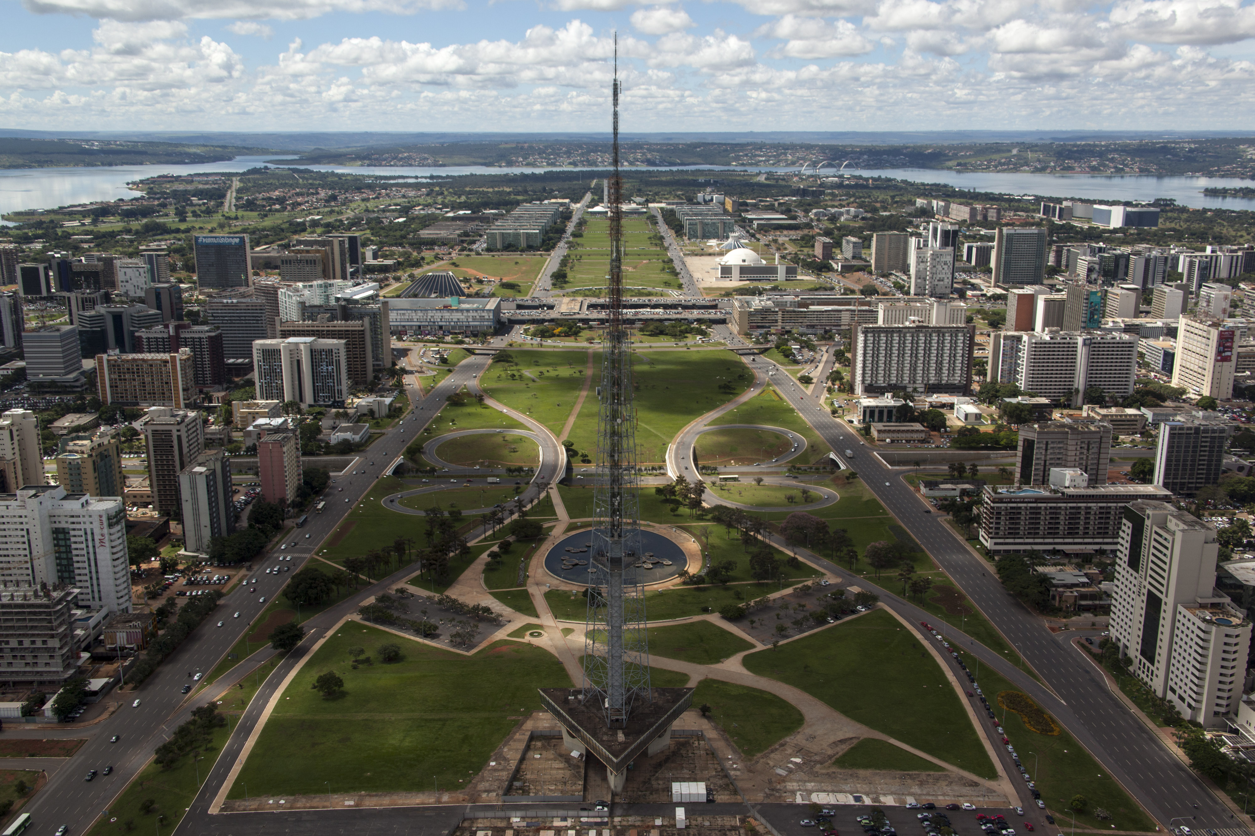
Monumental Axis and Brasilia TV Tower

Congresso Nacional

Brasília's Metropolitan Cathedral

Brasilia National Stadium

Cristo Redentor, Rio de Janeiro is an Art Deco statue of Jesus Christ in Rio de Janeiro, Brazil, created by French sculptor Paul Landowski and built by the Brazilian engineer Heitor da Silva Costa, in collaboration with the French engineer Albert Caquot. Romanian sculptor Gheorghe Leonida fashioned the face. The statue is 30 metres (98 ft) tall, not including its 8-metre (26 ft) pedestal, and its arms stretch 28 metres (92 ft) wide.

(M) The Teatro Amazonas is an opera house located in Manaus, in the heart of the Amazon rainforest in Brazil. The Amazonas Theatre was built during the Belle Époque at a time when fortunes were made in the rubber economic boom.

(M) The Praça Rio Branco or Marco Zero is a plaza located in Recife, capital of Pernambuco State.

(M) The Centro Cultural São Francisco is a religious complex located in João Pessoa, capital of Paraíba state, and it scares me because the plaza seems european places where the Inquisition burned and hanged people.
The Inquisition, however, didn't kill people here; they used other locations. Anyway, the Monastery had other history, Military. After the Dutch invasion, the building became a fortress, being restored due to the return of Franciscans. At the the 19th Century, the Monastery was again utilised for military purposes, becoming a Navy School and a Military Hospital through 1964.
Finally, the details of the chapel's interior are incredible. The altar, the paintings, the ceramic tiles.

(M) The Cathedral of Stone or Cathedral of Our Lady of Lourdes is a Catholic church located in the Brazilian city of Canela, Rio Grande do Sul. It is considered one of the major tourist attractions of the Serra Gaúcha. Its characteristic style is English Gothic, and it is considered one of the major tourist attractions of the Serra Gaúcha.
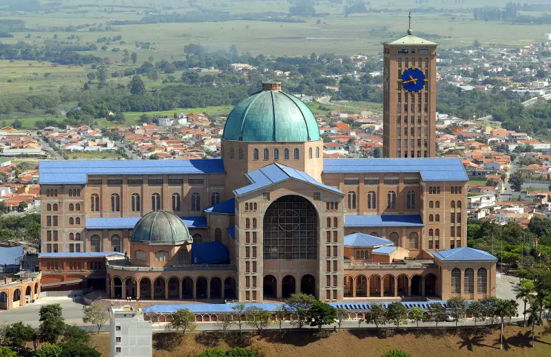
Cathedral Basilica of Our Lady Aparecida or National Sanctuary of Our Lady Aparecida is a Catholic temple located in the municipality of Aparecida, São Paulo. It's the bigger Catholic temple in Brazil and second in the world.

Igreja Santa Terezinha, Taubaté Taubaté is a medium-sized city in the State of São Paulo, in southeastern Brazil. Taubaté was part of the ancient Tupinamba Territory, along the Paraiba do Sul River.

(M) The Parque Farroupilha (Farroupilha Park), also known as Parque da Redenção or Rendenção, is a major urban park in the city of Porto Alegre, the state capital of Rio Grande do Sul.

(M) The Jardim Botânico de Curitiba (Botanical Garden of Curitiba), also known as the Jardim Botânico Fanchette Rischbieter, is a park located in the city of Curitiba - the capital of the state of Paraná - and the biggest city in southern Brazil.
The principal greenhouse, in an art nouveau style with a modern metallic structure, resembles the mid-19th century Crystal Palace in London. The Botanic Museum, which provides a national reference collection of native flora, attracts researchers from all over the world. It includes many botanic species from the moist Atlantic Forests of eastern Brazil.
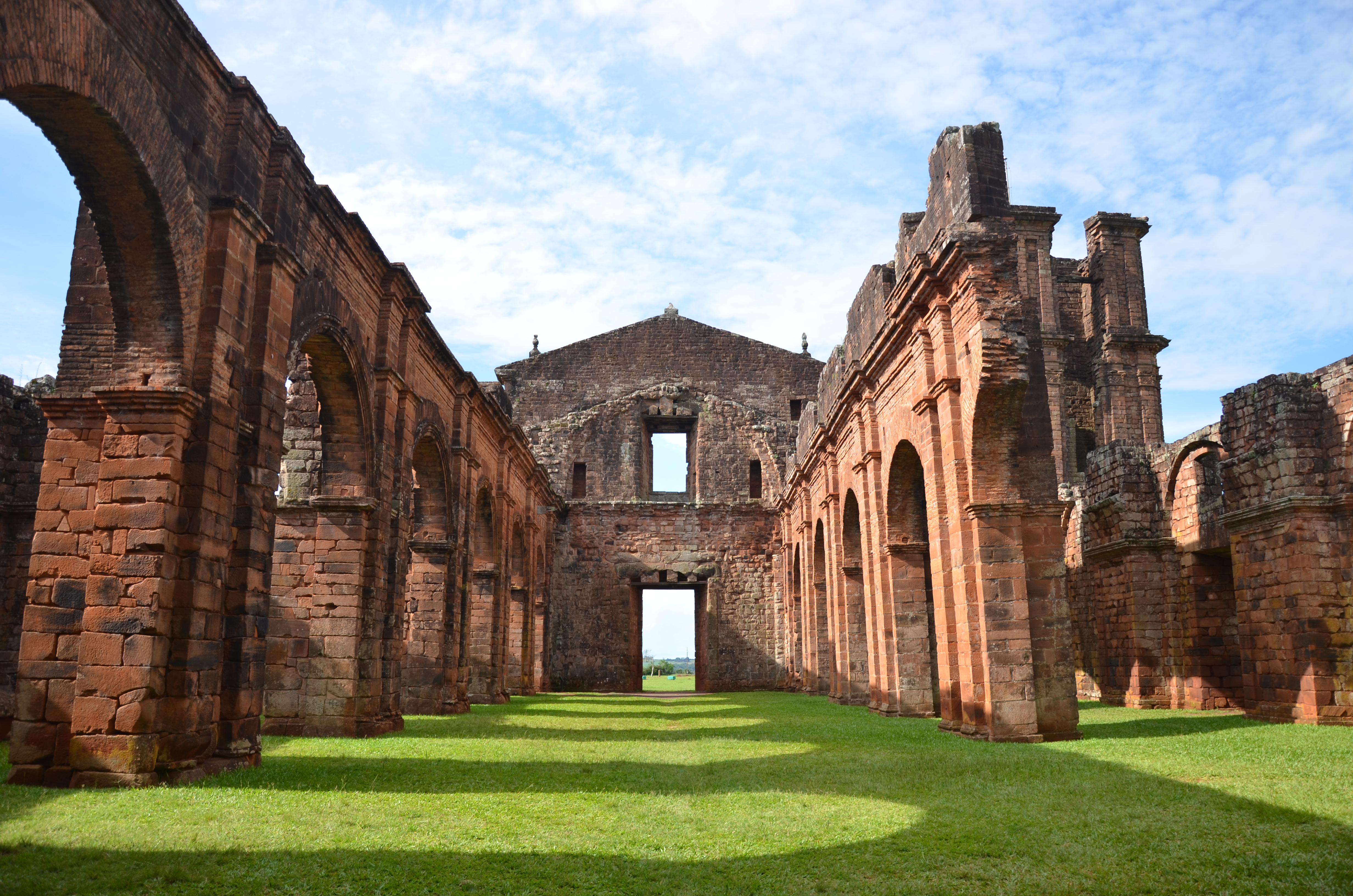
Ruínas de São Miguel das Missões
São Miguel das Missões is a municipality in Rio Grande do Sul state, southern Brazil. Important 17th century Spanish Jesuit mission ruins are located in the municipality. San Miguel Mission is within Sant'Angelo Microregion, and the Riograndense Northwest Mesoregion.

Plaza del Pelourinho - Salvador de Bahia
Salvador's Historic Center comprises the colonial city's primitive nucleus and its geographical expansion until the end of the 18th century. From Praça Municipal, open within the dense tropical forest by the first general-governor, Tomé de Sousa, in 1549, to largo de Santo Antônio Além do Carmo, battle field where Portuguese and Dutch soldiers from Companhia das Índias Ocidentais fought in 1638, monuments of civil, religious and military architecture make up a scenery that reveals Salvador's inhabitants art and way of living through the centuries. From Portas de Santa Luzia, which kept the southern boundary of the old city safe, with mud walls, to the thick walls of Fort Santo Antônio Além do Carmo, which guarded the north entrance, Salvador's Historic Center is divided in three areas that can be visited all at once: from Praça Municipal to largo de São Francisco, Pelourinho, and from largo do Carmo to largo de Santo Antônio Além do Carmo.

(M) Ouro Preto is a city in the state of Minas Gerais, Brazil, a former colonial mining town located in the Serra do Espinhaço mountains and designated a World Heritage Site by UNESCO because of its outstanding Baroque architecture.
Ouro Preto is located in one of the main areas of the Brazilian Gold Rush. Officially, 800 tons of gold were sent to Portugal in the XVIII century. Other gold circulated illegally, and still other gold remained in the colony to adorn churches and for other uses.
In the 18th century, Ouro Preto became for a time the most populous city in the New World, with an estimated population of 80,000 in 1750. At that time, the population of New York was half that number, and the population of São Paulo did not reach 8,000.

(M) Gramado is a municipality and small tourist town in the southern Brazilian state of Rio Grande do Sul. The town was originally settled by Azorean descendants and later received a contingent of German and Italian immigrants. Gramado is one of the towns along the scenic route known as Rota Romântica (Romantic Route).

(M) The Oktoberfest of Blumenau is a festival of Germanic traditions that happens in middle October in the city of Blumenau, Santa Catarina, Brazil. It is considered the biggest German festival of all Americas, and the one of the biggest Oktoberfest celebration along with the Kitchener-Waterloo Oktoberfest and after the original Oktoberfest from Munich.
With a relevant presence in Brazilian culture, the Germanic tradition has bases in states of Santa Catarina and Rio Grande do Sul with festivals, food, clothes, and architecture, sometimes classified as more preserved than in own Germany.

Sea shore of Santos/ SP
The gardens of the Santos coast, located in Santos, a Brazilian city on the coast of São Paulo, form the largest front beach garden in the world, and is a great source of biological resources and species of flowers and birds. The preservation and care with the flora of the praiano santista environment, permeated by palm trees and almond trees, are the result of a joint work of the environment departments of the region often linked to universities or biological institutions.
With 5,335 meters in length, width between 45 and 50 meters and 218,800 m² of area, this vegetation finishes the entire strip of sand, from José Menino to Ponta da Praia. Long lawns, together with palm groves and 19 isolated shrub species, give it a unique pattern. In 2002 it received the title of largest front garden next to the beach, by the Guinness Book, the Book of Records.

(M) The Açude Velho was originally a dam used for the supply of drinking water and for industrial activities in Campina Grande, Paraíba. In time, however, it has missed their original purpose, becoming a symbol of the city, surrounded by museums and monuments.
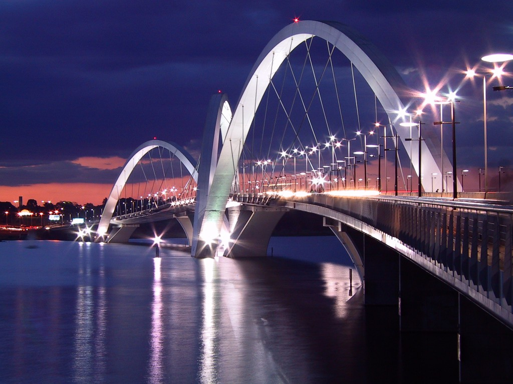
Juscelino Kubitschek Bridge. Brasília, also called President JK Bridge or JK Bridge, is a steel and concrete bridge crossing Lake Paranoá in Brasília. It links the eastern shore of the lake to the center of the city, through the Monumental Axis. Inaugurated on December 15, 2002, the bridge almost immediately became a symbol of Brasília, with its distinctive silhouette.

(M) Festa Junina (June Festival), also known as festa de São João for their part in celebrating the nativity of St. John the Baptist, are the annual Brazilian celebrations historically related to European Midsummer that take place in the beginning of the Brazilian winter. The feast is mainly celebrated on the eves of the Catholic solemnities of Saint Anthony, Saint John the Baptist, and Saint Peter.
As Northeastern Brazil is largely arid or semi-arid these popular festivals not only coincide with the end of the rainy seasons of most states in the northeast but they also provide the people with an opportunity to give thanks to Saint John for the rain. They also celebrate rural life and feature typical clothing, food, dance (particularly quadrilha, which is similar to square dancing).
Two northeastern towns in particular have competed with each other for the title of "Biggest São João Festival in the World", namely Caruaru (in the state of Pernambuco), and Campina Grande (in Paraíba state). In picture, we have the São João at Campina Grande.

(M) The Lençóis Maranhenses is a national park located in Maranhão state. Composed of large, white, sweeping dunes, at first glance Lençóis Maranhenses looks like an archetypal desert, but in fact it is not an actual one. Lying just outside the Amazon Basin, the region is subject to a regular rain season during the beginning of the year. The resulting blue, green and black "lagoons" are surrounded by the desert-like sand, and reach their fullest between July and September.

(M) The National Park of Serra da Capivara is a preservation unit located in the State of Piaui. It’s considered an open-air museum with 737 archaeological and fossil sites, being 64 released to public view.

(M) The State Park of Jalapão is located in Tocantis State. Jalapão is a savanna with rivers, waterfalls, lagoons, sand dunes, hills, and plateaus.

(M) The Pedra Azul (Blue Stone) is a rock outcrop of gneiss located in Domingos Martins, Espírito Santo. The city of Domingos Martins is a part of Serra Capixaba, a region with strong influence of Italian, Pomeranian, Germanic, and Finnish traditions.

(M) The Mount Roraima is a table-shaped mountain located in Roraima State and on the Triple Frontier between Guyana, Venezuela, and Brazil. It's bordered by steep cliffs height up to 1000m.
First described by the English explorer Sir Walter Raleighm during his expedition in 1595, the mountain received any expeditions, but its flora, fauna, and geology remained unknown for centuries, which apparently inspired Sir Conan Doyle and his book The Lost World.

(M) Chapada dos Veadeiros is an ancient plateau, with an estimated age of 1.8 billion years, and a national park of Brazil. Chapada dos Veadeiros is noted for its waterfalls, its rock formations, one of the oldest on the planet, and its rich fauna, some of which are threatened by extinction.

(M) Chapada Diamantina is an erosional landform in Bahia state. This same chain receives other names, like Serra do Espinhaço, in Minas Gerais, and Borborema, in Pernambuco and Paraíba.
The breathtaking landscape, its huge canyons with rivers of brownish waters, the high altitude grasslands, known locally as Gerais, innumerous waterfalls and a great extent of trails, once used by miners in their search for diamonds, makes it one of the best destinations in Brazil for the practice of outdoor activities.
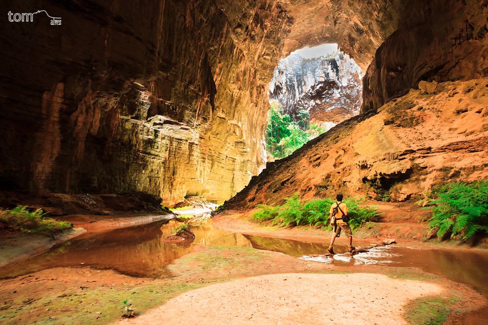
Parque Nacional Cavernas do Peruaçu
Caverns National Park Peruaçu is a conservation unit established in 1999 whose main objective is to protect this valuable geological and archaeological heritage that exists in this region. With an area of 56,800 ha, is located approximately 45 km from the city and 15 km from Januária Itacarambi in the northern region of Minas Gerais. With easy access, paved roads and in good condition can reach his seat.
The source data for millions of years, even when part of Brazil was submerged by the waters of an inland sea and that with the rising of the earth has dried out the water. This whole process has left a large mass of limestone which today are home to thousands of caves spread throughout Brazil. The Peruaçu River, a tributary of the Rio Sao Francisco, was closed by its natural course of such a massive and with time the erosive action of water was carving the limestone, in search of an exit.
The action of time resulted in a set of caves, many still virgins, which has attracted cavers caves in search of yet cataloged. The public visitation must be made with great care not to damage the speleothems that took millions of years to form.

(M) Areia Vermelha is a state park located in Paraíba State. The center of the park is the Ilha de Areia Vermelha (Red Sand Island). It appears during the low tide combined with natural pools and reefs, all surrounded by a light green water.

(M) Jijoca de Jericoacoara is municipality in the Brazilian state of Ceará. It is famous for its homonymous beach and national park. The word Jericoacoara comes from Tupi (an indigenous language) and means "house of turtles." The location has favorable conditions for windsurfing and sandboarding.

(M) Fernando de Noronha is an archipelago of 21 islands and islets in the Atlantic Ocean. The area is a special municipality of the Brazilian state of Pernambuco. In 2001 UNESCO designated it as a World Heritage Site because of the importance of its environment.
The islands of this archipelago are the visible parts of a range of submerged mountains. It consists of 21 islands, islets and rocks of volcanic origin. The life above and below sea is the main attraction of the island. Sea turtles, cetaceans (most common among these are spinner dolphins and humpback whales, followed by many others such as Pantropical spotted dolphins, Short-finned pilot whales, Melon-headed whales), albatrosses and many other species are frequently observed.

(M) Mouth of the Paraíba River.
In this place was founded the military fortress of Santa Catarina and the municipality of Cabedelo, becoming the gateway to the state of Paraíba. There French pirates fought against Natives, Portuguese settlers fought against Natives and French pirates, Dutch invaders fought against Portuguese settlers, Dutch settlers fought against Portuguese invaders and Natives, African slaves were introduced.
The Paraíba River estuary still remains nowadays as an important entry for the state, being the Cabedelo harbor.

(M) Sunset at Praia do Jacaré (Caiman Beach)
The image portrays the sun rising and setting in the River Paraíba. It’s the sunset of Praia do Jacaré (Caiman Beach). During all the setting sun, Jurandy do Sax plays the Boléro of Maurice Ravel using a saxophone.

(M) Pedra do Tendó (Stone of Tendó)
This picture is a view of Pedra do Tendó (Stone of Tendó), a granite rock on abyss of Serra de Texeira (Texeira Mountain), where we can see the most party of Paraíba’s low uplands (backlands) and some municipalities of Patos metropolitan zone. An incredible view during the morning and evening of a land colonised by New-Christians, Gypsies and a range of different people.

Staging of the Foundation of Vila de São Vicente
"Here Comes the World's Largest Beach Sand Show ..." considered by the Guinness Book.
Carried out 36 years ago, the Foundation of the Vila de São Vicente tells the story of the creation of the First City of Brazil, dated January 22, 1532. In 2017, the city will celebrate 485 years.
The show has become a cultural heritage and national reference in regard to the rescue of historical memory and the exercise of citizenship. It is held at Praia do Gonzaguinha, in the exact location of the navigator's landing and founder Martim Afonso de Souza, in 1532.(I predict fights with those who are near Porto Seguro and Cabralia...rs)

Guarujá, the atlantic pearl
Known as the "Pearl of the Atlantic", due to its beaches, some urbanized and others wild, accessible only by trails in the middle of the Atlantic Forest, as well as for its natural beauties, historical heritage and excellent tourism infrastructure, Guarujá is highly sought after Tourists from all over the world.
Guarujá is a city with numerous attractions that go beyond its 27 beaches. Beaches good for bathing and water sports and water, with calm sea in some parts and full of waves in others allow the practice of surfing and at the same time guarantee fun with the family. The city has great cultural and architectural resources, such as the historical forts of Andradas (Monduba beach), Itapema (in Vicente de Carvalho) and the fortress of Santo Amaro da Barra Grande, in Santa Cruz dos Navegantes, among others. There is also the building Sobre las Ondas, postcard of Guarujá, located on the beach of Pitangueiras and which was recently listed by state historical patrimony.
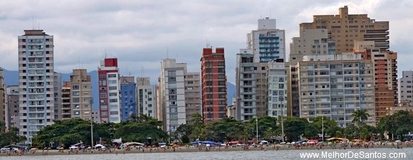
Bent buildings of Santos
No, your eyes are not fooling you. More than 90 buildings from the 40s, 50s and 60s on the Santos coastline are thus mainly between channels 3 to 6, where the composition of the city's soil (made up of layers of sand and clay) is the main cause of the slope of the Buildings. The pressure exerted by buildings built in the neighborhood also helps to further bend the buildings.
You cannot miss some Brazilian girls...


...or the Brasil fans!


The winner of the Brasil's Picture Contest is Munganga
The final top 3 were as following:
7. Pedra do Tendó (Stone of Tendó) - 42 vote points
5. Mouth of the Paraíba River. - 39 vote points
1. Sea shore of Santos - 27 vote points
Globe Trotter Itinerary


I have invitations for following countries. I will apply to them as soon as I am finishing with the previous one. If you want me to come to your country and think you can support me in getting CS please send me a message and I will add your country to the list.


I also have promises for support in getting CS for next countries. As I mentioned before, if I will receive a direct invitation, that will mean more interest for the project, so I will add/move the country to the previous list.


[Shout]
Globe Trotter in Brasil!
https://www.erepublik.com/en/main/article/2623641
You definitively should not miss this one!
Comments
Pertañax
I´ll be back 😛
Industria Brasileira approved this comment
Holy smokes. That is awesome.
v
v
voted, wonderful 😃
Hello homie, great job but you made a mistake:
The big church picture contains a description about "Taubaté". The description is right but that's not an image from Taubaté.
The church is called "Basilica de Nossa Senhora Aparecida" and, after Vaticano, it's the biggest catholic church in the whole world
I apologies; corrected
Voted! o/
V!
Very nice!
huszonot o7
The 9th image is not Taubaté, it is Aparecida.
It is the largest Catholic temple in Brazil and the second largest in the world, smaller only than the Basilica of St. Peter in the Vatican.
a 9° imagem não é Taubaté, é Aparecida.
É o maior templo católico do Brasil e o segundo maior do mundo, menor apenas que a Basílica de São Pedro no Vaticano.
I apologies; corrected
Voted!
Nice, voted!
votat
Great country!
Thanks for a wonderful walk to you 🙂
So nice and good explanations of what and where. 🙂
Oh my god... beautiful pics 🙂
And still, many places are still missing.... Brazil is such a wonderful country with its natural landscapes and its originality with all the different cultures that joined there.
😉
good job Munganga & Silexu
Nice
Very nice country.
Hope to visit some day 🙂
D+
BRASIL!
vote 😃
OMG... Great! \o/
o7
The National Park of Serra da Capivara - como nosso lugar em Ruse regiao, cidade Cerven! 🙂
Votado!
Ouro Preto
Lugares lindos
A wonderful country. Thanks for sharing this article. o/
V
v
voted!
v80
o7
NEXT .... colombia ❤
I would lovely come if this is an official invitation. Still I have 2 countries in the queue.
YES OFC, invitation official :3
nice 🙂
V
Nice, voted!
V!! 07
V + E
Really? An article about beatty in Brazil without Iguassu Falls?
The Iguassu Falls (Cataratas do Iguaçu) are one of the new natural wonders in the world.
Google it!
http://www.cataratasdoiguacu.com.br/
The Iguazu River rises near the city of Curitiba. For most of its course, the river flows through Brazil, however, most of the falls are on the Argentine side.
They are presented in Argentina article. Please check it in the Itinerary.
And there are enough other beautiful places presented.
I understand your point. It is like to say: Niagara Falls belongs to Canada article.
But, despite most of the falls are on the Argentine side, as you said, the better sight is in Brazilian side. I know, I've been there many times.
After all, I just want to contribute with your article.
See you.
Without Iguassu falls, Amazonas River, Itaipu, Pantanal, a hundred pictures of Rio and Salvador, but all those places are famous.