
Fix your map projection
 •
by
•
by chickensguys
Fix your Map projection
A combination of gross negligence and/or pure ignorance is the reason why I have decided to write this article.
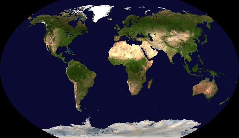
Have you ever looked at the eRepublik map on the homepage?
Did you notice the size the Greenland?

Greenland is approximately 836,300 sq miles in real life, but according to the map projection it is larger than America and even larger than Africa.

To put this in perceptive Africa is over 11 MILLION Sq miles in real life. This map projection is showing Greenland a country that is at least 14 times smaller than Africa, larger than it! Even Alaska for instance, is grossly out of portion, while Alaska is the largest state in America, according to the map projection it could encompasses over a 1/2 of America. However in reality you could fit roughly 3 states the size of Texas in Alaska, hardly ½ of America.
Why you should care
This was fairly common with most Northern Hemisphere maps in the early colonial years but in this day in age we should know better. Having such a skewed map projection is not only dishonest; it changes how people view the world. Reality itself is only a matter of perception, so if we teach a generation of people that Africa is basically the size of Greenland we are doing them a disservice. In a world that is based more and more on equality, we are basically teaching the world that 3rd world countries should be valued less. The reason for that is because size and importance have been synonymous with each other. In other words we are disenfranchised the world.
In a short funny 4 minute YouTube clip that I ask you to watch on the bottom of the page, it even suggests that such a distortion in the map fosters imperialistically behavior. Something to think about I suppose.
Solutions
Use a combination of map projections to find one that is relatively correct.
Like this one for example,
or this one

Here is a nice clip on Map projections. Very enjoyable
http://www.youtube.com/watch?v=n8zBC2dvERM
-Dr. Walter Bishop
Comments
Lol
True story bro, but don't expect it to be ever fixed xD
A touch of retentive maybe?
The last episode of season 5,sukked ass hard 😕
I assume you are talking about Fringe....
Please Confirm
You assumed rite cha xD
You and that bald ass autistic kid fell through the time portal and ... It just fuqn' ended 😕
The ending it self was great, the problem I had was with how the timeline would operate in terms of the early observers. It created a few paradoxes, that shouldn't exactly exist.
I agree it was the great ending whatsoever,but I hoped I'll get to see what happened to those who survived,you know,some kind of a short epilogue. Too bad a show like this one had to end (so soon) :- /
voted + shouted + loved
V/s/s
Also; are there any plans to remove the old map?
It is still classified as a BETA version, so in all likely hood some changes will follow. That being said, I do not know the details of what the admins plan to do.
V + S for anal-retentiveness. 😃
Now youre nit picking
OK any way that you attempt to flatten the globe onto a 2 dimensional plane, SOMETHING is going to end up getting skewed.
You can have a map like erep uses, which stretches the poles out to the width of the equator
You can have a map like you suggest which skews lands at the edges of the map at an angle and has gaping edge of the world zones
You can have a map with splits coming down from the poles at intervals like you see in textbook maps
You CAN'T transfer an accurate portrayal of the entire surface of a 3 dimensional ANYTHING onto a 2 dimensional ANYTHING. It defies physics.
That said it would be interesting and impressive if eRep were to come up with an animated, rotatable 3 dimensional flash globe. But, that probably won't happen if for no other reason than to ensure all players computers and internet connections can continue to handle this simple interface game.
Well I do admit perfection may not be viable, I do know they can certainly do better than this.
Incorrect map is incorrect. Other incorrect map is also incorrect. Which incorrect map is better? Neither; this argument is an excercise in pointlessness. At best its a matter of personal preference.
If you want to know what the world really looks like, find a globe, heres a digital one: earth.watype.net/en/globe/. Otherwise, just work with the 2d maps while maintaining acute awareness of the nature of their inaccuracies.
Anyone who understands geography is aware that Greenland is not the size of Africa, and that Antarctica is not a long strip of white at the bottom edge of the world. ...and that... there are no edges of the world. ...
Here there be monsters!
It was a worthwhile article to raise awareness of this issue. Some people really didn't see anything wrong with this choice of map projection, and now they know the land areas are clearly wrong and they have a chance to question their perspectives.
Your statement defies all logically thinking. Black and White thinking is rarely practical, certainly you are smarter than this. Asking for a remotely correct map is not outrageous.
Its eRepublik, what do you expect?
It's no better than the current map. Besides, note that ePlato has also moved eTransilvania...it no longer has any border to eHungary and is totally enclosed within eRomania, more 'revisionist history'..
Transilvania has no border in RL with Hungary! 😁 Look better at the map, and then u come here and tell us that u are upset of somethink REAL this time, that this game should implement..
You must have missed Trianon.
eRomania's map is correct right now.
Then why has it changed from V1, where eHungary could invade eTransilvaia directly without having to go through the new phony 'buffer zones'?
[removed]
[removed]
Becouse that map was not the real-life one, Transilvania is in the hearth of Romania, you have to pass through Banat or Crisana to arrive in it, or if u come from the North, Maramures or Bucovina, from the South - Muntenia, Oltenia, Dobrogea
lolz u dont get it bro. Greenland is where Plato lives 😁 he owns the biggest continent from eRep! such a badars!!
Great article! ( v 132)
And Fringe rocks!
[removed]
I noticed that immediately myself. I was gonna say something, but then I figured if I did, the admins would probably
Exactly right. After all we're all the same species and in an enlightened age we should be open to the truth without cultural bias.
On a lighter note, check out this map which is much more accurate for erepublik:
http://tinyurl.com/d5w75ho
lol
~hyuu~
I agree that Mercator projection shouldn't have been their first choice, but does it really matter all that much?
Someone has been watching 'The West Wing' LOL!
http://www.youtube.com/watch?v=vVX-PrBRtTY
LOL
Plato Fail!
Well, either alternative you proposed is flawed too. In the first one, Antarctica is roughly the size of all the other continents combined, whereas in the second one it doesn't even appear!
Another interesting article about the old map this time:
http://www.erepublik.com/en/article/-new-map-known-issues-2201372/1/20
It's the Mercator Project, which while horrible distorted, is incredibly useful for navigation.
http://en.wikipedia.org/wiki/Mercator_projection
>fosters imperialistically behavior
Butthurt liberals.
You miserable, coplexed guy...
What stupid idea! Lets talk about perpective, curving, globe and 2 dimensional map
[removed]
lololol
[removed]
The point of the last maps was to focus on the map projection itself. Not the regional division.
And why do you seperate the USA, the Canada and Mexico while you could just call it north America ?
You don't show Brazil but you make the difference between the USA and Canada ?....
http://interculturalmeanderings.files.wordpress.com/2011/07/the-world-according-to-america-2.png